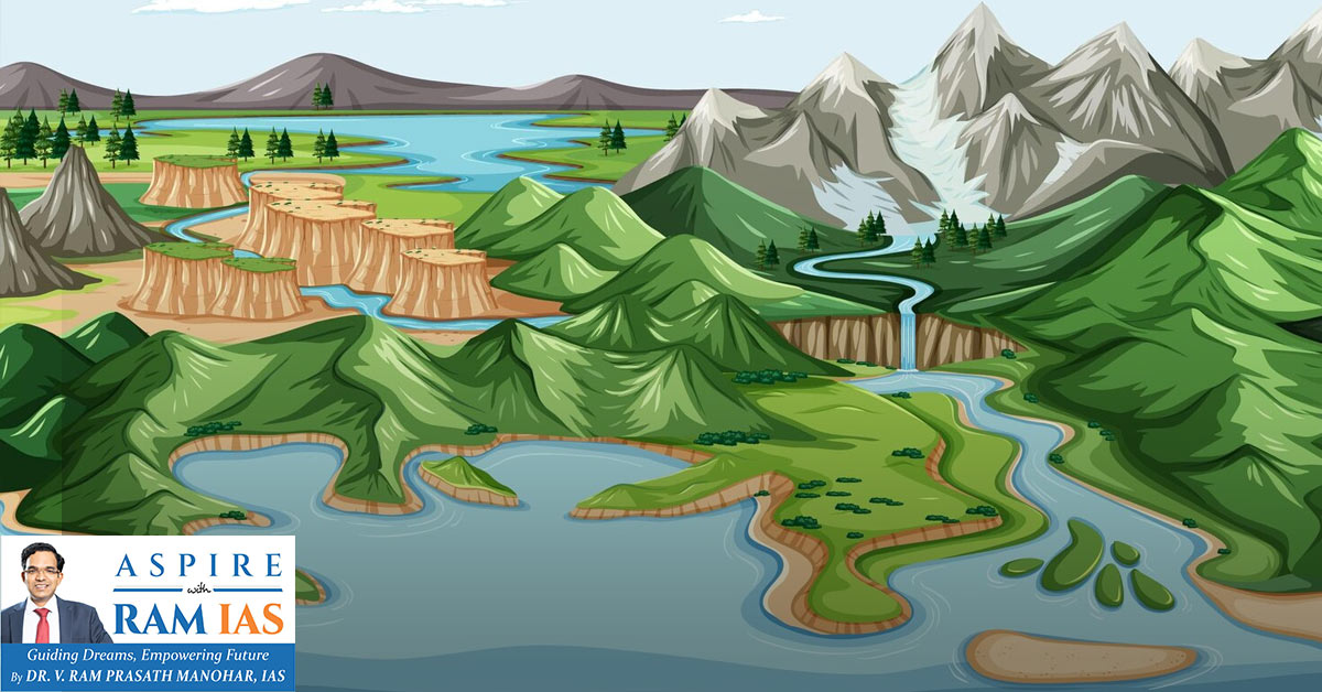
Fluvial landforms are created by running water (rivers). Rivers drain nearly 68% of Earth’s land surface and act as major agents of erosion, transportation, and deposition.
I. BASIC CONCEPTS
Drainage Basin
- Area drained by a trunk river and its tributaries.
- Also called a catchment/watershed.
- Acts like a funnel collecting runoff.
Drainage Divide
- Ridge separating adjacent drainage basins.
- Prominent in youthful topography (e.g., Himalayas).
Consequent Stream
- The initial stream flows down the original slope.
II. FLUVIAL EROSION
Types of River Erosion
- Hydraulic Action – Mechanical loosening of rocks by water pressure.
- Abrasion/Corrasion – Rock fragments strike and wear the bed & banks.
- Attrition – Rock fragments collide and reduce in size.
- Solution/Corrosion – Chemical dissolution of soluble rocks.
- Downcutting – Vertical erosion (valley deepening).
- Lateral Erosion – Sideward erosion (valley widening).
- Headward Erosion – Upstream extension of the valley.
III. STAGES OF RIVER COURSE
Youth Stage
- Dominant vertical erosion.
- Deep, narrow V-shaped valleys.
- Features: Gorges, Canyons, Waterfalls, Rapids.
- Poorly developed floodplains.
Mature Stage
- Lateral erosion dominates.
- Wider valleys.
- Meanders develop.
- Floodplains begin forming.
Old Stage
- Deposition dominant.
- Extensive floodplains.
- Oxbow lakes, levees, deltas.
- Low gradient & heavy sediment load.
IV. FLUVIAL EROSIONAL LANDFORMS
1. Valleys
V-Shaped Valley
- Formed by vertical erosion.
- Narrow & deep.
Gorge (I-shaped Valley)
- Deep, narrow valley with steep sides.
- Example: Indus Gorge (Kashmir).
Canyon
- Wider at the top, step-like slopes.
- Common in horizontal sedimentary rocks.
- Example: Grand Canyon (USA).
2. Waterfalls & Rapids
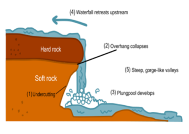
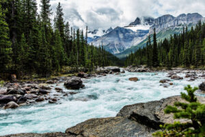
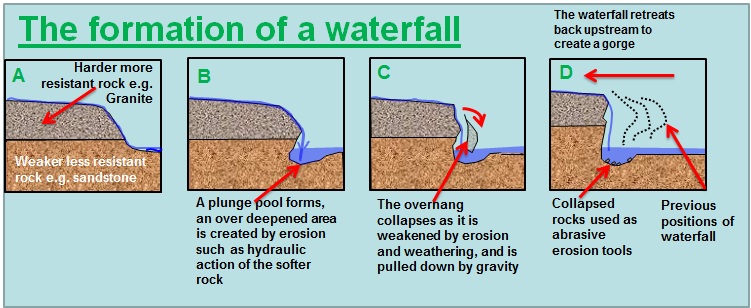
- Formed due to differential erosion.
- Create plunge pools.
- Recede upstream over time.
- Large waterfalls on major rivers are called Cataracts.
3. Potholes & Plunge Pools
- Circular depressions in rocky river beds.
- Formed by rotating pebbles.
- Large ones at the waterfall base = plunge pools.
4. Interlocking Spurs
- Alternating projections of high land in V-shaped valleys.
5. River Terraces
- Old floodplain levels.
- Indicate rejuvenation.
- Paired terraces occur at the same level on both sides.
6. Incised/Entrenched Meanders
- Deeply cut meanders in hard rocks.
- Result of rejuvenation or uplift.
7. Structural Benches
- Step-like valleys.
- Due to the differential erosion of hard & soft rocks.
8. Peneplain
- Almost level surface.
- Represents near-final stage of fluvial erosion.
V. DRAINAGE PATTERNS
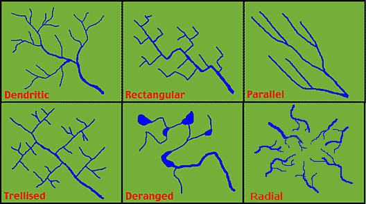
Dendritic
- Tree-like pattern.
- Example: Northern Plains rivers.
Trellis
- Right-angle tributaries.
- Found in folded mountains.
Radial
- Streams flow outward from the central high.
- Example: Amarkantak.
Centripetal
- Streams flow inward to the depression.
- Example: Loktak Lake.
Rectangular
- Right-angle bends due to jointed rocks.
Parallel
- On steep slopes.
Annular
- Circular pattern around domes.
VI. FLUVIAL DEPOSITION
Occurs when river velocity decreases (lower course).
VII. FLUVIAL DEPOSITIONAL LANDFORMS
1. Alluvial Fans
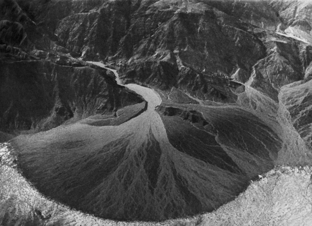
- Cone-shaped deposits at mountain foothills.
- Coarse sediments were deposited first.
- Steeper in arid regions.
2. Floodplains
- Formed by repeated flooding.
- Built by layers of silt & clay.
- Active & Inactive floodplains.
3. Natural Levees
- Raised embankments along river banks.
- Formed by coarse sediments during floods.
- Example: Yellow River (China’s Sorrow).
4. Meanders & Oxbow Lakes
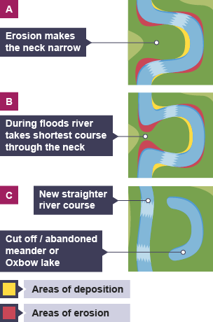
- Erosion on the concave side → Cut bank.
- Deposition on convex side → Point bar.
- Cut-off meander forms Oxbow Lake.
5. Braided Channels
- Multiple channels separated by bars (eyots).
- Occur with high sediment load & low velocity.
6. Delta
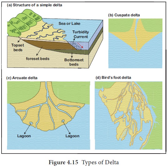
Definition
Fan-shaped deposit at the river mouth.
Conditions
- High sediment supply.
- Shallow sea.
- Weak tides & currents.
- No large lakes upstream.
Types
- Bird’s Foot Delta – Example: Mississippi River
- Arcuate Delta – Example: Nile River
- Cuspate Delta – Example: Ebro River
- Estuarine Delta – Example: Amazon River
VIII. DOAB
- Land between two rivers.
- A common term in the Indo-Gangetic plains.